Miklabraut Highway Cap
Development on and around a road cap for Miklabraut by Snorrabraut.
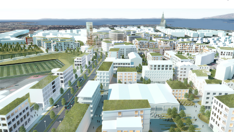
Here you can check out the proposals of five interdisciplinary groups on how to implement the development on and around a road cap on Miklabraut by Snorrabraut. The proposals are the results of an idea search announced by Reykjavík City in 2020.
Which proposal do you like the most and why?
The proposals show the appearance and development possibilities of a significant new residential and commercial area on top of the cap and in its immediate vicinity, and how the development together with a CityLine center station connects to nearby neighborhoods and the surroundings.
Reykjavík City has the authority to further develop these proposals, modify them and/or delegate their implementation to others. This is, therefore, a kind of idea bank for possible implementation in the next round of development for this large-scale project.
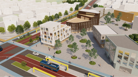
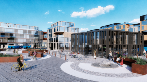
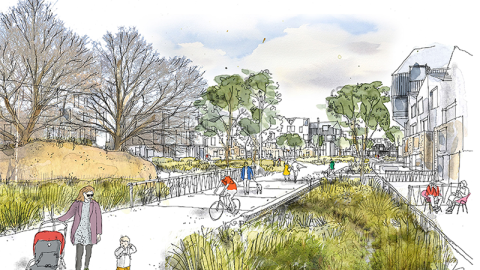
01.
Proposal by Arkís, Landslag, and Mannvit.
Miklatorg Square is a new, diverse center offering trade, services, and commercial premises mixed with various types of dwellings. The trajectory of CityLine harmonizes well with this new, dense urban layout, acting as one of the central strategies in its evolution.
The proposal portrays a 3-5 story construction using the forms and aesthetic of the developed neighborhoods surrounding Miklatorg. Hence, the pattern of peripheral buildings is most evident in the south and west parts of the area, closest to Hlíðarendi, with detached buildings becoming more common closer to Hlíðar and Norðurmýri.
02.
Proposal from Yrki arkitektar, Dagný Land Design, and Hnit verkfræðistofa.
The new development on top of the highway cap connects residential districts in Hlíðar with Norðurmýri and Hlíðarendi, binds the neighborhoods together and plans for a new neighborhood core - the central station of the CityLine. The central station will provide services for the residents and create a new attraction in the area.
The large outdoor recreation areas of Klambratún and Öskjuhlíð are connected through Hlíðarendi by smaller public parks and squares with pathways for people.
03.
Proposal from Teiknistofan Tröð, Kanon arkitektar, and VSÓ ráðgjöf.
The focus is on integrating the neighborhoods of Hlíðar, Norðurmýri, Þingholt, and Hlíðarendi with an emphasis on environmentally friendly transport, building a mixed-use neighborhood with human-scale standards, and accessibility to diverse public spaces. The neighborhoods north and south of Miklabraut converge into a new district at Hlíðarendi and the Landspítali plot, along with a new area atop the highway cap.
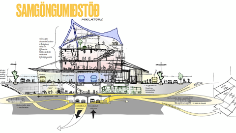
04.
Proposal from T.Ark, Verkís, Studio Wgret West, and Integrated Transport Planning+
We propose a three-story traffic system. At the bottom is Miklabraut, then Bústaðavegur under the surface, and at the surface, the CityLine. In addition to Miklabraut in the cap, Bústaðavegur is therefore connected to Snorrabraut in a cap as well as the on and off-ramps under the new surface.
05.
Proposal of Askur arkitektar, Efla, and Gagarín.
Miklatorg is at the heart of the idea, located east of Snorrabraut. It stretches towards Landspítali, "Brooklyn", Klambratún, and Hlíðarendi. This is a confluence of daily life in the city. It is bustling with people coming and going with different intentions.
The hospital is one of the main players, both universities, connection to the airport, sports activities in Hlíðarendi and the outdoor recreation areas in Öskjuhlíð and Klambratún. This area also links the neighborhoods that surround it.