02 Proposal for the Miklabraut Cap
Proposal from Yrki arkitektar, Dagný Land Design, and Hnit verkfræðistofa.
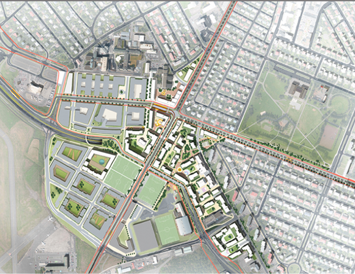
The new development on top of the highway cap connects residential districts in Hlíðar with Norðurmýri and Hlíðarendi, binds the neighborhoods together and plans for a new neighborhood core - the central station of the CityLine. The central station will provide services for the residents and create a new attraction in the area.
Explanation images
What are your thoughts?
The large outdoor recreation areas of Klambratún and Öskjuhlíð are connected through Hlíðarendi by smaller public parks and squares with pathways for people.
One of the main goals is to ensure that the new development best adapts to nearby neighborhoods and logically connects them.
Thus, the new development respects the adjacent neighborhoods, ensuring the heights and sizes of buildings fit well with the existing environment.
Philosophy
The idea is to create a high-quality development that unifies nearby neighborhoods and creates a core community for them. The new development is seamlessly incorporated into the current neighborhoods and developed around the Landspítali, Norðurmýri, Hlíðarendi, and Skógarhlíð. This new development offers services that both new and current residents within the area will benefit from. An increase in population and improved connections support commercial activities.
A video showing Miklabraut in a highway cap – Proposal from Yrki arkitektar, Dagný Land Design, and Hnit verkfræðistofa.
High-quality development can be achieved by focusing planning and design in such a manner that basic services for daily needs are within a 10-20 minute walking distance from home.
Highway cap implementation
The main traffic of Miklabraut, in east and west directions, goes into a cap under Snorrabraut. Snorrabraut is then extended over the highway cap to Arnarhlíð and Nauthólsvegur.
Traffic toward the west along Bústaðavegur goes over the highway cap and across Miklabraut where it then merges with the western flow of the route. Traffic on Bústaðavegur going east joins Miklabraut in a cap under Snorrabraut and then into a separate lane which connects where Bústaðavegur is now at Flugvallarvegur.
New development on top of the cap
The new development on top of the highway cap connects residential districts in Hlíðar with Norðurmýri and Hlíðarendi, binds the neighborhoods together and plans for a new neighborhood core - the central station of the CityLine.
The central station will provide services for the residents and create a new attraction in the area.
The large outdoor recreation areas of Klambratún and Öskjuhlíð are connected through Hlíðarendi by smaller public parks and squares with pathways for people.
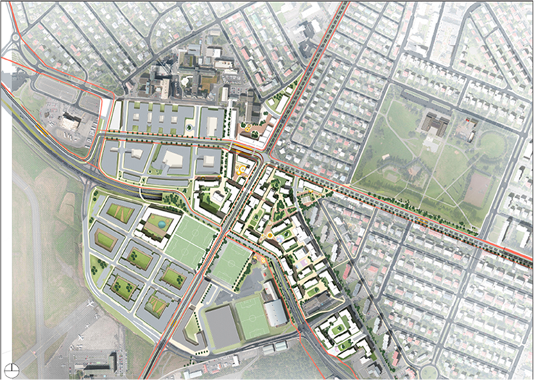
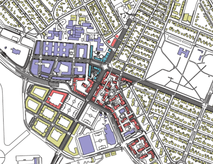
Distribution of structures
Light green - Dwellings
Purple - Services
Red - New dwellings
Green - CityLine Central Station
Neighborhood characteristics
One of the main goals is to ensure that the new development best adapts to nearby neighborhoods and logically connects them. Thus, the new development respects the adjacent neighborhoods, ensuring the heights and sizes of buildings fit well with the existing environment. The buildings then shape an interesting interplay of courtyards, playgrounds, and squares that are connected by paths and streets.
Parks and public spaces
Emphasis is placed on using spaces between buildings for shared parks, playgrounds, and public squares for residents and visitors. The placement of buildings and their layouts create interesting, diverse and sunny spaces between them.
Newer developments also include smaller squares and gardens (for instance playgrounds) that benefit the nearby residents.
New neighborhood center
The introduction of CityLine into the neighborhood, creates an even stronger connection for residents to other parts of the city and the capital area.
The CityLine's central stations are transport hubs where heavy pedestrian traffic can be expected.
The stations are important connection points in the Strætó and CityLine route network.
This creates new opportunities for commerce and services that rely on heavy foot traffic.
This encourages the operation of commerce and services in and around the central stations.
The plan is, therefore, to locate the majority of shops and services in and around the central station, thereby creating a new neighborhood center.
The central station
The CityLine's central station is located at the eastern end of the Landspítali plot where a parking garage is currently planned.
Much traffic to and from the hospital can be expected as it is one of the largest workplaces in the country and a large number of people seek its services daily.
It is therefore crucial to connect strong public transport with the hospital.
The station is next to a building housing shops and services on the ground floor with hospital offices located above it.
The central station has underground parking, making the station a major transportation hub for the area, for Landspítali, staff, visitors, and residents, regardless of mode of transport.
New transportation hub, BSÍ
A new transportation hub, BSÍ, is planned near the CityLine's central station. It's from here that buses will depart for and from Keflavík Airport ('airport shuttle') and other scheduled trips outside the capital area.
A waiting area for buses and coaches is planned on the ground floor of a building north of the central station. The ground floor is open to Burknagata and functions like an open parking garage, exclusively for buses and coaches. Above the waiting area will sit Landspítali's office building.
This will be an overall transportation hub with a large number of passengers due to proximity to Landspítali, CityLine's central station, BSÍ and the densely populated city center.
The CityLine's central station, in conjunction with BSÍ, makes all connections between bus routes from Keflavík Airport and organized coach travel from outside the capital via the Strætó Public Transport and CityLine systems easier. Visiting Reykjavík, or making short trips away, can be done without the need for a car.
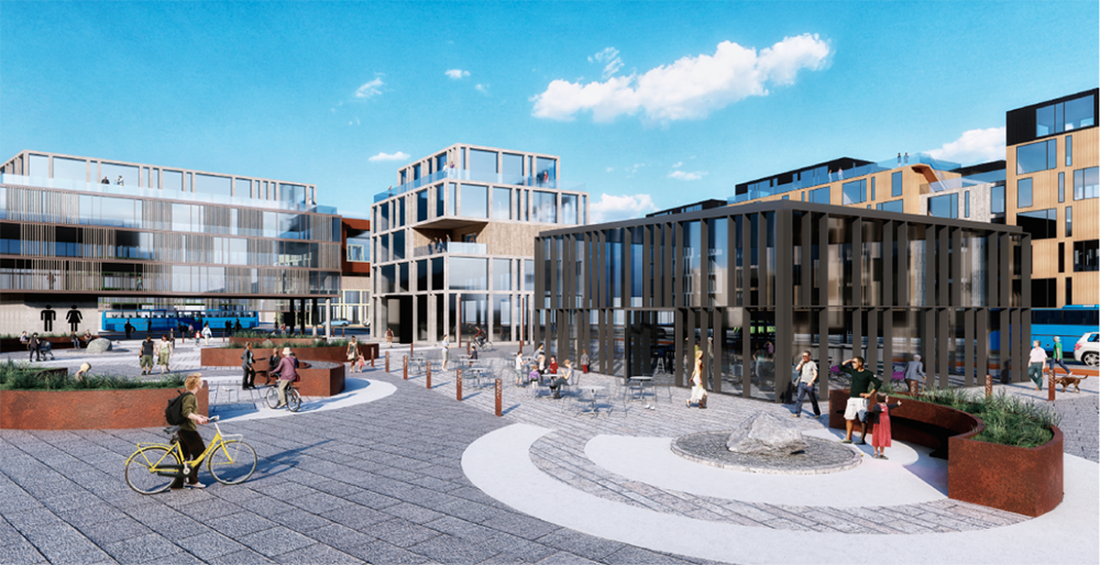
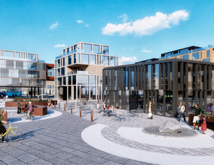
Herdísartorg Square
The CityLine central station is situated at Herdísartorg, where nearby cafés and restaurants may extend their operations onto the square. Herdís Bersadóttir was the first wife of Snorri Sturluson for whom Snorrabraut is named. The square is especially sunny, opening to the south and west. Additionally, the adjacent buildings provide good shelter from northern winds.
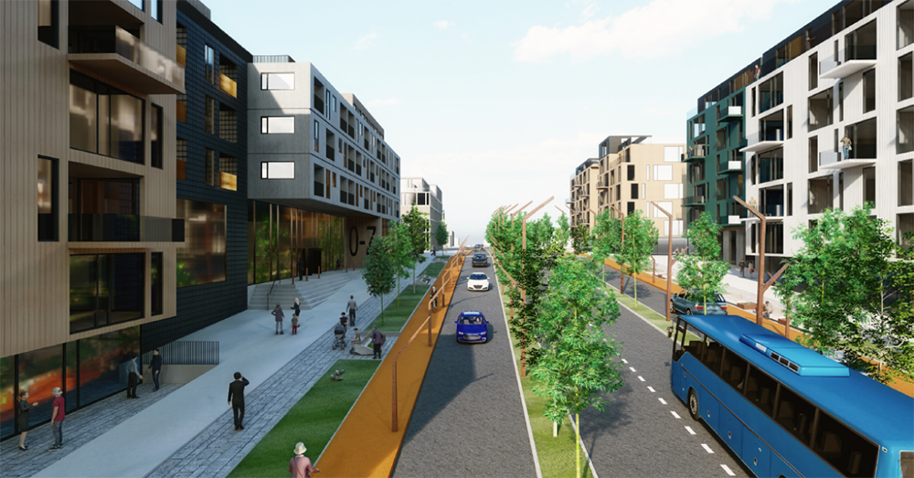
Snorrabraut shopping street
The extension of Snorrabraut will be the lifeline of the new development with shops, services and dwellings.
The central station is located by the street and separate CityLine lanes run through the middle of the street in conjunction with car lanes. Biking paths extend all along Snorrabraut which connects the coastal path at Sæbraut to Nauthólsvík and Fossvogur.
Pedestrian and cycling traffic
As stated before, the proposal is primarily on the terms of pedestrians. Pedestrians move slower and thus have more opportunities to experience and perceive their surroundings better. Special attention is paid to having a dense network of walking paths along streets and paths between public parks so that the area offers both efficient walking paths to move along, as well as a good and diverse experience for people who want take a longer route home.
A site plan for the Miklabraut Highway Cap
The proposal envisions bike paths along the CityLine.
As a result, there will be main paths along upper Miklabraut (on top of the cap), Burknagata, Snorrabraut, and Nauthólsvegur.
Bike paths from Sæbraut to Nauthólsvík along Snorrabraut connect the coastal path at Sæbraut to Nauthólsvík and Fossvogur.
From there, it will then be possible to cycle to Kársnes over the new bridge, Fossvogsbrú.