04 Proposal for the Miklabraut Cap
Proposal from T.Ark, Verkís, Studio Wgret West, and Integrated Transport Planning+
We propose a three-story traffic system. At the bottom is Miklabraut, then Bústaðavegur under the surface, and at the surface, the CityLine. In addition to Miklabraut in the cap, Bústaðavegur is therefore connected to Snorrabraut in a cap as well as the on and off-ramps under the new surface.
Explanation images
What are your thoughts?
This approach aims to both open the area for new development and to ensure the flow of pedestrians, cyclists, and CityLine, as well as maintain traffic flows to and from the area.

The idea
Our proposal is based on ensuring all traffic that currently crosses this area but doesn't need to access the neighborhood should be routed below the surface. By relocating this rift below ground level, there is potential to shape a new landscape connecting neighborhoods and forming a unified whole.
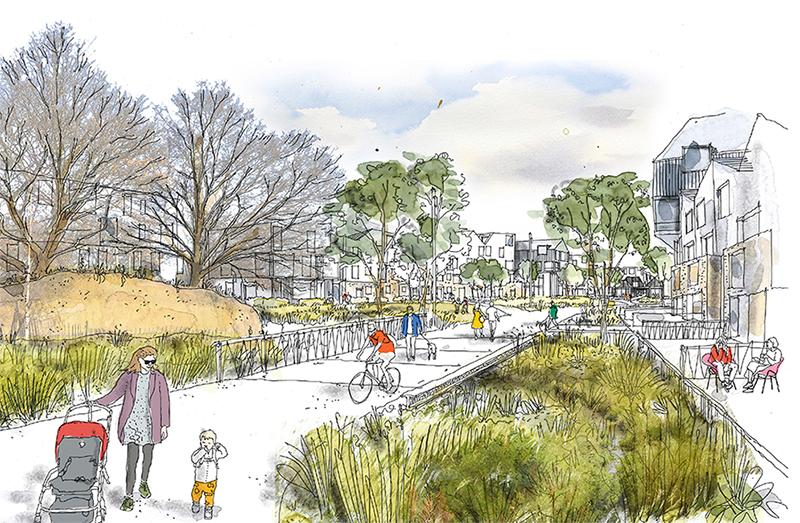
Once through-traffic and movement to and from Landspítali have been redirected from local traffic, even more opportunities arise to connect the neighborhoods and ensure safer routes for cyclists and pedestrians. Instead of heavy traffic on Miklabraut, there is now a landscape and structures blending with the environment on both sides. The surface area will be holistic.
A new neighborhood will be created, defined by village charm, quiet traffic, and life between buildings, drawing the neighborhoods closer together. A fantastic opportunity arises for both daily life and construction while keeping essential traffic routes and connections in the highway cap.
Highway cap implementation
We propose a three-story traffic system. At the bottom is Miklabraut, then Bústaðavegur under the surface, and at the surface, the CityLine. In addition to Miklabraut in the cap, Bústaðavegur is therefore connected to Snorrabraut in a cap as well as on and off-ramps.
On the west side, the lowering of Miklabraut starts at the current pedestrian bridge.
To the east, the lowering of Miklabraut begins near the intersection of Langahlíð, resulting in easy access from Hlíðar to Klambratún at the end of the cap. There will be two lanes in each direction. The layout of the cap will largely follow the current course of Miklabraut, but with a softer curve at Rauðarárstígur, moving the cap slightly south. Therefore, the buildings at Miklabraut 18-20 have to give way.
To the south, Bústaðavegur descends at Skógarhlíð 8. To the west, the lowering of Bústaðavegur starts at Snorrabraut 81, with the intersection at Eiríksgata remaining open. In the plan, Bústaðavegur will follow its current course. There will be one lane in each direction towards Snorrabraut but on and off-ramps will be separate lanes.
Connections between Bústaðavegur and Miklabraut
The connections between Bústaðavegur and Miklabraut will be as follows: South from Bústaðavegur to the west on Miklabraut, the connection will be similar to the current ramp. The ramp will be in the same place but positioned deeper and under a roof. From Miklabraut from the west to Bústaðavegur to the south, there will be a ramp in a curve under the surface. No other connecting lanes will be constructed between Bústaðavegur and Miklabraut.
Surface
On Snorrabraut, between Burknagata and Eiríksgata, the traffic will look significantly different from today. In the center of the street, there will be one lane in each direction, with the lanes descending into the Bústaðavegur cap. On both sides, roads for general traffic will be at the same level with CityLine/bus in a mixed system. General traffic will go west to Burknagata, but there will be no connections for general traffic east to Miklabraut, that road will solely serve CityLine/bus.
At the intersection of Snorrabraut and Burknagata, CityLine/bus will be able to drive onto Snorrabraut, Burknagata/bus stop and up onto/off Miklabraut towards the east.
Skógarhlíð will be extended to Gunnarsbraut, with connections to new buildings westward. All these connections are designed as shared space roads, where cyclists, pedestrians, and vehicles coexist.
Urban layout
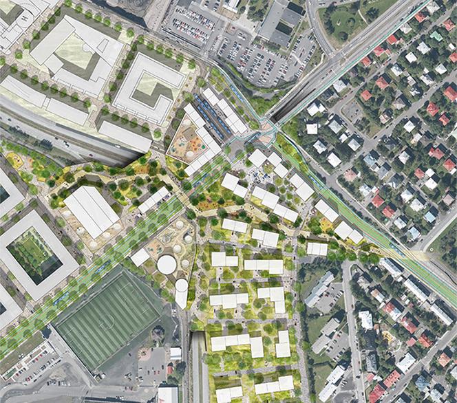
The urban layout is designed to transition from fragmented peripheral blocks at Skógarhlíð, mirror the scale of Eskihlíð apartment buildings, and adapt to 2-3 story multi-family dwellings in Norðurmýri, with a gradual tapering of building heights in between. Skógarhlíð will have residential construction with diverse boundaries and building fragmentation, emphasizing visual experience and pedestrian connections throughout the area.
The new neighborhood is characterized by a village-like charm, tranquil traffic, and vibrant life between buildings.
Miklabraut Station
At the southern end of Snorrabraut, where many routes of CityLine converge, we choose to locate the Miklabraut Station. The station occupies a key location, where city center and residential areas meet, creating an exceptional opportunity to make the edge of downtown more vibrant.
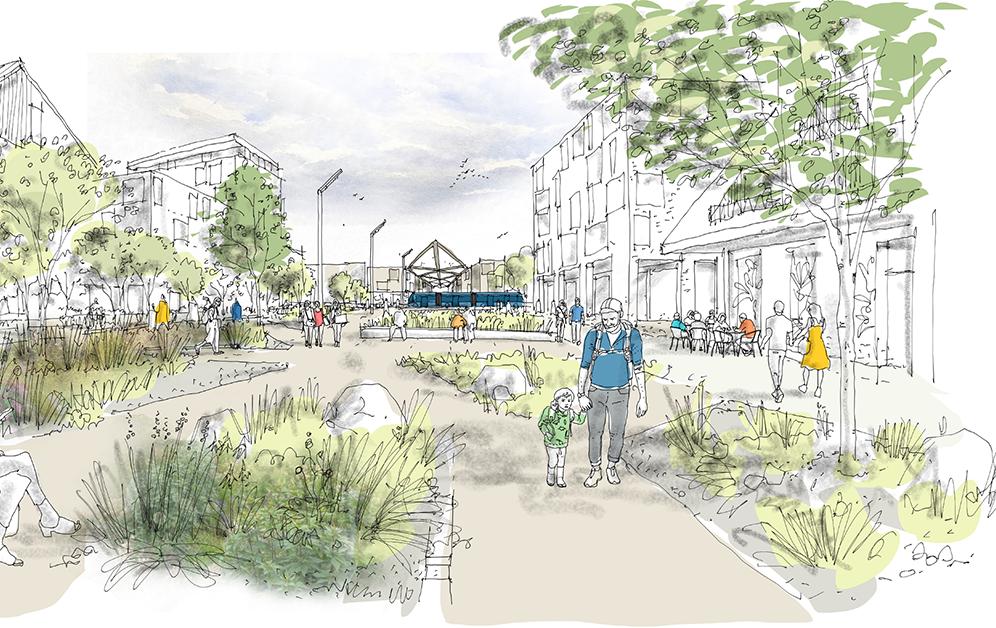
CityLine drives through the covered station, and transfers between routes will occur under a roof. The route goes from east to west, providing shelter from cold winds from the sea. In addition to being a center for public transportation, there is also provision for a service hub with shops, cafés, and other activities.
Miklatorg Square
South of CityLine station and in an extension of it, there is a new square. Surrounding the square are 2-3 story buildings with shops on the lower floors and businesses or dwellings on the upper floors. The square will be a social hub that combines services, commerce, and the CityLine station.
We envision a square with defined green spaces, but primarily with tiled ground, and mostly on shared space premises, where CityLine drives across the square into the station and both merge into one, parallel to Gustav Adolfs square in Gothenburg, or the Nörreport area in Copenhagen. In this way, the square's activity flows in line with view the viewing line south towards Nauthólsvegur and north along Snorrabraut.
Miklatorg will become a social hub that combines services, commerce, and the CityLine station.
Green link
South of the buildings defining the south side of the square, there's a nature area, the garden Hvammur. It emphasizes leisure and transport, connecting routes to and between outdoor recreation areas such as Klambratún, Öskjuhlíð down to Nauthólsvík, the Valur area, and Vatnsmýri. Our vision is that this grassy hollow bridges and connects neighborhoods and other green areas, ensuring safe access from neighborhoods to the Valur area and other outdoor areas.
To the east of the area, the walking paths and the square merge with a shared space road connecting Skógarhlíð with Gunnarsbraut. This ensures the arrival of service vehicles and accessibility-impaired to the square, as well as direct access between neighborhoods on shared space roads with pedestrian speed.
Contact us
Email: skipulag@reykjavik.is
The project falls under the jurisdiction of the Office of the Planning Officer at the Department of Environment & Planning of Reykjavík City.


