01 Proposal for the Miklabraut Cap
01. Proposal by Arkís, Landslag, and Mannvit
Miklatorg Square is a new, diverse center offering trade, services, and commercial premises mixed with various types of dwellings. The CityLine route complements this new, densely developed cityscape, serving as one of the pivotal strategies in shaping it.
Explanation images

More about the proposal
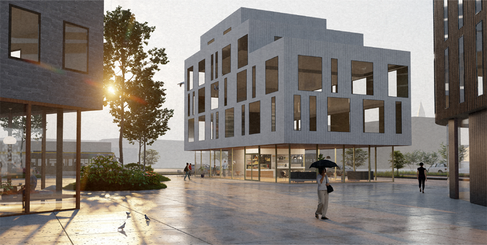
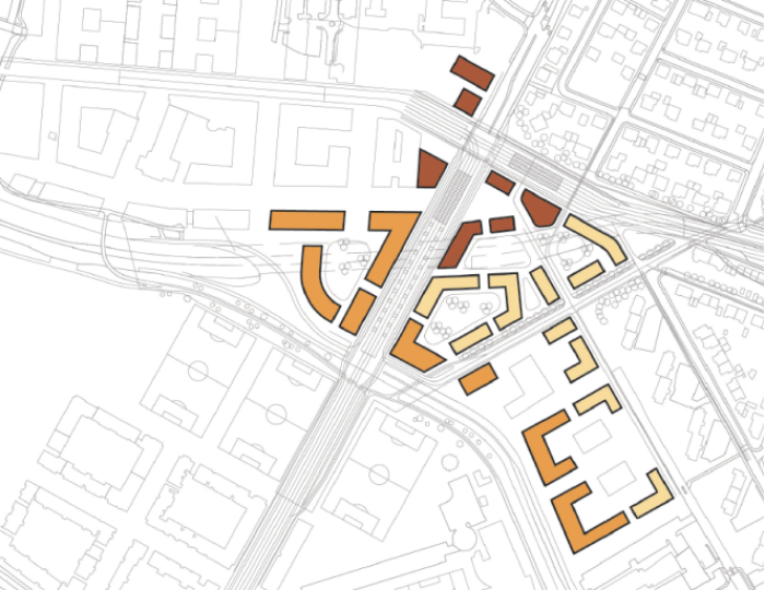
The proposal portrays a 3-5 story construction using the forms and aesthetic of the developed neighborhoods surrounding Miklatorg.
Hence, the pattern of peripheral buildings is most evident in the south and west parts of the area, closest to Hlíðarendi, with detached buildings becoming more common closer to Hlíðar and Norðurmýri.
You can explore the Arkís proposal in more detail and participate in a survey about it.
The missing puzzle piece
The area south of Norðurmýri has many manifestations in its short history of approximately 100 years of urbanization in Reykjavík. Currently, it is split by heavy traffic making access to green spaces difficult.
Neighborhood core
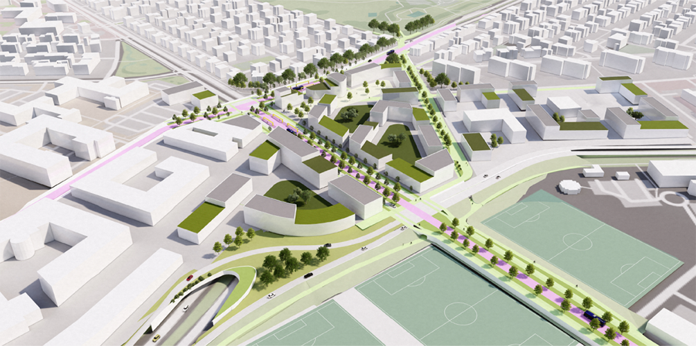
Miklatorg will be a new neighborhood core tying together Norðurmýri, Hlíðar, Hlíðarendi, and Þingholt, including through the property of the New Landspítali. Miklatorg also serves as a critical connection point of these neighborhoods with other neighborhoods in the city and the capital area as a whole.
The development of this new central area is made possible by the addition of the Miklabraut Highway Cap, which connects the previously mentioned neighborhoods in a continuous urban pattern, prioritizing safe and attractive routes for environmentally friendly modes of transport. Miklatorg is the missing puzzle piece to connect the urban pattern of Norðurmýri, Hlíðar, Hlíðarendi, and Þingholt/New Landspítali.
Highway cap implementation
The cap is on one level, lying where Miklabraut/Hringbraut is today. Two lanes in each direction. Snorrabraut lies on the surface above the cap (crossing the cap) and connects to Bústaðavegur at surface-level intersections. Snorrabraut has four lanes, two lanes for CityLine and two for car traffic. Snorrabraut is connected to Bústaðavegur and Arnarhlíð at surface-level intersections north of the end of Hlíðarendi.
Bústaðavegur lies north of Hlíðarendi and connects to Snorrabraut and Arnarhlíð at traffic light-controlled intersections. Bústaðavegur connects to Hringbraut via on and off-ramps by the side of the tunnel opening to the west.
Miklabraut Highway Cap
In accordance with the Transportation Charter of the capital area, it is planned for Miklabraut to be capped. Through traffic is thus directed underground, while public transport and slow neighborhood traffic coexist harmoniously with other modes of transport above ground. This will improve air quality and reduce noise pollution, both within the neighborhood and in nearby neighborhoods. Improved pedestrian flow on the surface will encourage the use of more environmentally friendly modes of transport and enhance the cityscape.
Urban layout
Miklatorg Square is a new, diverse center offering trade, services, and commercial premises mixed with various types of dwellings. The CityLine route complements this new, densely developed cityscape, serving as one of the pivotal strategies in shaping it. The proposal portrays a 3-5 story construction using the forms and aesthetic of the developed neighborhoods surrounding Miklatorg. Hence, the pattern of peripheral buildings is most evident in the south and west parts of the area, closest to Hlíðarendi, with detached buildings becoming more common closer to Hlíðar and Norðurmýri. This pattern anticipates that workplaces could be located on the southern and western edges of the area. Dwellings are on the inside and sheltered from the noise of Bústaðavegur and the tunnel entrance of Miklabraut Highway Cap. Mixed development is expected near Miklatorg itself, at the intersection of Snorrabraut and Hringbraut.
Path system
Emphasis will be placed on a dense network of walking and cycling trails within the neighborhood while ensuring that Miklatorg Square is well connected to adjacent neighborhoods and paths. There will also be an emphasis on good transit cycling paths through the neighborhood along main transport routes and ensuring a good and safe mixture between all unprotected road users.
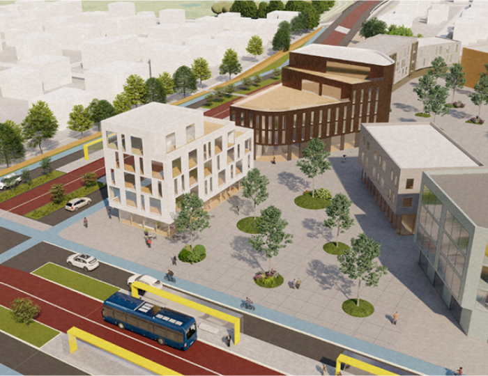
Near the intersection of Snorrabraut and Hringbraut will be an prominent CityLine central station, which offers seamless transfers between different CityLine routes and buses. Miklatorg itself is a sheltered, sunny square that is as accessible as possible.
CityLine
At Miklatorg, there will be a CityLine hub that makes public transportation to and from the neighborhood swift, regardless of traffic congestion. To the west, the CityLine route will go all the way to Harpa and the University of Iceland in a designated space, and to the east, the route will go to Grafarvogur and Mosfellsbær.
Heading south, the CityLine route will go over the Kársnesbrú bridge to Kópavogur, Garðabær, and Hafnarfjörður. This will make Miklatorg a bustling hub where people will seize the opportunity to run errands, shop or meet up during their daily travels.
The square and central station
The square will be surrounded by spaces for shops, services, and catering that ensure a high level of service and contribute to a pleasant, efficient, and sheltered passenger journey across the area.
Green areas and ecosystems
Miklatorg is a green oasis over the busy main road, forming a continuous green connection between Vatnsmýri, Klambratún, and Öskjuhlíð. It significantly increases the city's variety of opportunities for outdoor activities. Pedestrian, running, and bike routes connect effortlessly. Also, children and other athletes can safely get to and from the sports fields at Hlíðarendi. There is an emphasis on a green path that connects Klambratún and the sports field at Hlíðarendi clearly.
The green path plays a vital role in managing surface water with sustainable drainage solutions. Along the path, there will be resting and experience places. The former Hagkaup building could potentially serve a purpose on the path in a reconstructed and improved form, for example, as a café and for cultural and community activities.
Development potential
Miklatorg connects established neighborhoods and those under development. The establishment of Miklatorg and Miklabraut Highway Cap provides a calmer and more appealing environment for nearby neighborhoods. The environmental quality markedly improves by reducing the traffic load on Miklabraut. Service availability within the neighborhood increases, and the overall surroundings become safer and more sustainable. It's expected that this might increase the value of properties in the area. A boost in property value in the area should subsequently promote better upkeep and care.
Furthermore, the establishment of Miklatorg increases the possibilities for development in the peripheral areas of nearby neighborhoods. For example, the proposal shows the potential for better utilization of land between Bústaðavegur and Skógarhlíð, and on the edge of the New Landspítali area on Snorrabraut.
Area use:
- Dark brown: Mixed
- Light brown: Career
- Light: Dwellings
Contact us
Email: skipulag@reykjavik.is
The project falls under the jurisdiction of the Office of the Planning Officer at the Department of Environment & Planning of Reykjavík City.