03 Proposal for the Sæbraut Highway Cap
Proposal from Teiknistofan Tröð, Kanon arkitektar, and VSÓ ráðgjöf.
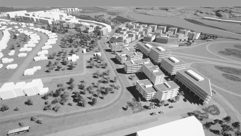
The main idea is to connect the old buildings in Vogar with the new Vogabyggð and Elliðaárvogur. The emphasis is on diverse public spaces, sustainable transportation, and mixed construction on a humane scale without disruption from the main road traffic of Sæbraut, which goes into a cap. A new public space - "Ramblan" - on top of the cap will unite the existing neighborhood of Vogar and the new Vogabyggð neighborhood.
Details
The first phase of CityLine crosses the area, and a new central station will be built on the highway cap at its southern end. Much of the new housing expected to arise due to the overlaying of Sæbraut in a highway cap will envelop this station. The central station is located at Súðarvogur, on the border of the oldest and new construction in the South. Suðurlandsbraut will be extended into Vogabyggð to allow for westward travel from Vogabyggð.
A video showing Sæbraut in a highway cap – Proposal from Teiknistofan Tröð, Kanon arkitektar, and VSÓ ráðgjöf.
Guiding principles
Transforming the Sæbraut highway into a cap at Vogatorg Square and Vogabyggð helps integrate the neighborhoods into a cohesive whole and provides stronger connections to Elliðaárvogur and Elliðaárdalur areas. The area on top of the Sæbraut Highway Cap is unique, in part due to its proximity to mature residential areas, robust industrial zones, and potential for development in the Municipal Plan. The weather there is uniquely pleasant. Safe, beautiful access enhances the quality and is suitable for developing a modern and sustainable urban environment in harmony with the surrounding neighborhoods. The development of residential, commercial, and industrial buildings in connection with the cap and the central station strengthen the area on both sides of Sæbraut, making the two neighborhoods a cohesive whole - with vibrant streets, urban spaces, and green areas.
The design of routes and mobility for pedestrians, cyclists, and public transportation is prioritized on the surface of the cap while inside the cap, there is unrestricted flow for car traffic.
Cap execution
As you travel north on Sæbraut, the cap starts north of the loop ramps in Ártúnsbrekka, before arriving at Dugguvogur.
The cap ends north of the intersection of Skeiðarvogur and Kleppsmýrarvegur.
There will be ramps for car traffic to enter and exit the cap at the intersection of Skeiðarvogur and Kleppsmýrarvegur.
Suðurlandsbraut curves to the north and will cross over the cap and will connect to Súðarvogur in Vogabyggð.
Private car traffic crosses the cap at Skeiðarvogur, the extended Barðavogur, Snekkjuvogur, and Suðurlandsbraut. A biking and walking path is planned on top of the cap. The length of the cap is approximately 750m.
Ramblan, a garden between neighborhoods
Vogahverfi and Vogabyggð join into one, whole neighborhood, with a new public space on top of the cap. The public space takes its cue from La Rambla; it's about 600 meters in length and 40 meters in width; and features diverse outdoor areas and generally pleasant weather. La Rambla is the center-point of the neighborhoods, encouraging daily life activities and serving as a venue for diverse usage for locals and visitors depending on the season.
“La Rambla” is a park that will be on top of the cap between neighborhoods.
Neighborhood characteristics
The plan for the site is to have mixed three to five story high residential and commercial buildings.
The aim is to have between 1,000 and 1,300 apartments plus commercial buildings in a ratio of 30% to 70% residential construction.
The southern part of the area, to the east and west of tunnel opening, is characterized by dense, three to five-story peripheral block buildings that are highest next to the main roads.

A mix of commercial and residential housing is planned. Towards the east at the bank of Elliðaá shows tower blocks, this would primarily have apartments. Current buildings at Knarrarvogur will be replaced by new five-story buildings.
At the northern tip near Skeiðarvogur, there is an iconic structure, a building that is planned to mainly cover ramps for entrance and exit intersections at Skeiðarvogur and Kleppsmýrarvegur. The building will also provide shelter from the prevailing northern winds on good weather days.
Contact us
Email: skipulag@reykjavik.is
The project is under the jurisdiction of the Planning Officer at the Department of Environment & Planning of Reykjavík City.