Land-use plan of Arnarnesvegur
The proposal for the new detailed plan of Arnarnesvegur Phase 3 will be introduced on March 3, 2022, at 5pm during a live-streamed meeting, and the deadline to submit comments has been extended to March 11.
The meeting will be hosted by Reykjavík City, Kópavogur and the Icelandic Road and Coastal Administration, and in addition to their representatives, there will be representatives from the engineering firm EFLA, which is the counselor for the detailed plan.
The land-use plan proposal
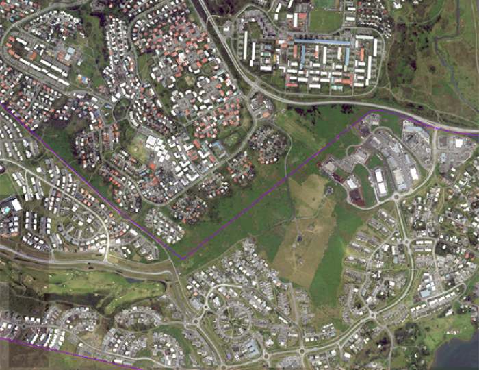
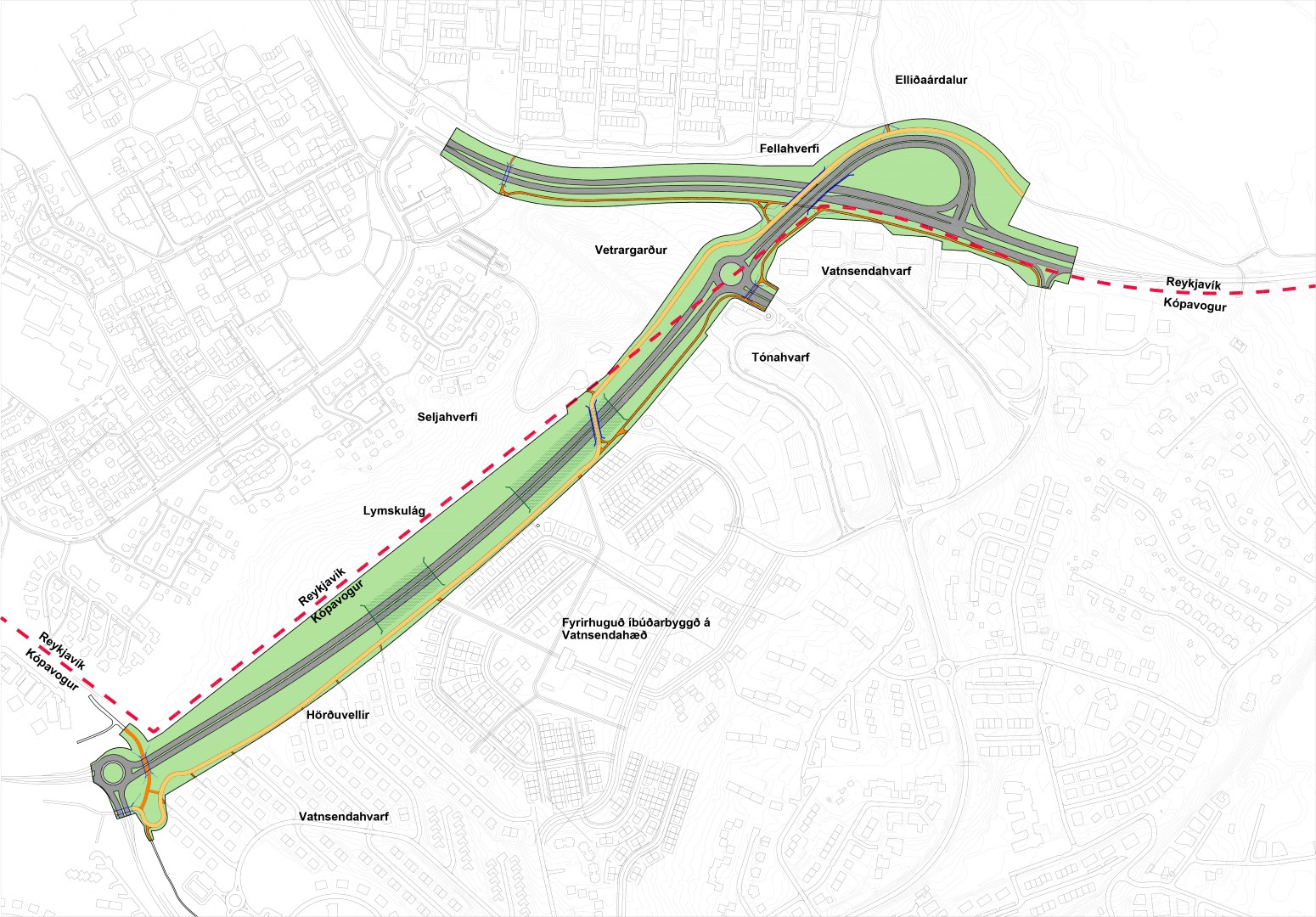
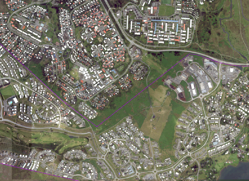
The land-use plan proposal extends to parts of Arnarnesvegur, a new road with two lanes in each direction, walking and biking paths, along with two new roundabouts, from the intersection of Arnarnesvegur and Rjúpnavegur to the planned intersection of Breiðholtsbraut and Arnarnesvegur and its right-of-way area, which extends typically 30 meters out from the centerline of the road.
You can familiarize yourself with the proposal below and send inquiries in advance to the email: skipulag@reykjavik.is or skipulag@kopavogur.is. We will attempt to answer them during the meeting. You can also send inquiries while the stream is live.
Live-streamed meeting
Explanation images
The land-use plan.
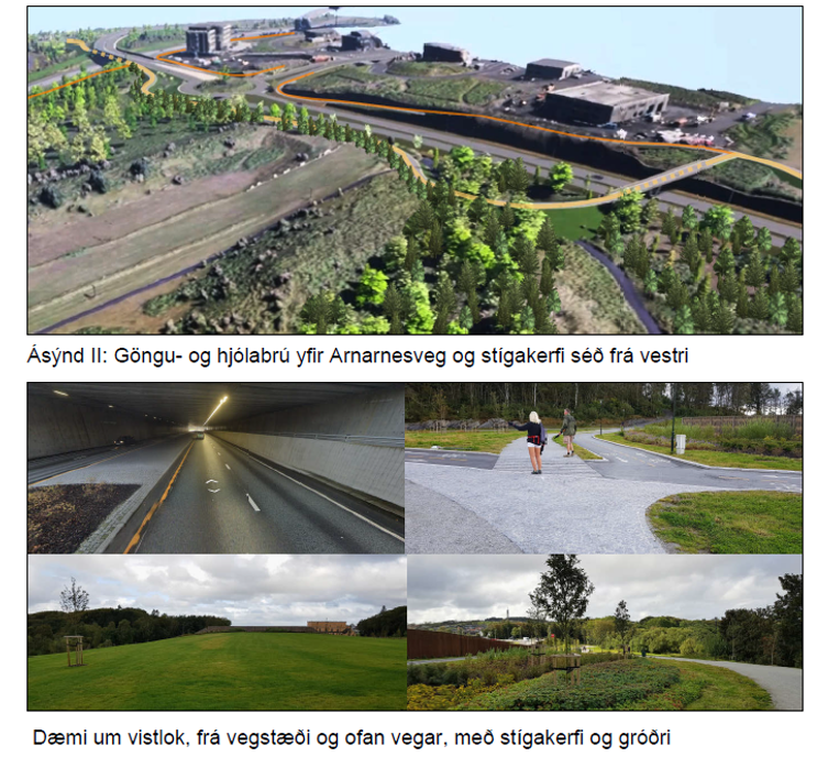
Reykjavík City and Kópavogur jointly work on a detailed planning in accordance with Article 37 of the Planning Act No. 123/2010 for the third phase of Arnarnesvegur, from the intersection of Arnarnesvegur and Rjúpnavegur to the planned intersection of Breiðholtsbraut and Arnarnesvegur. The main purpose of the construction of Arnarnesvegur is to connect the peripheral areas of Reykjavík, Kópavogur, and Garðabær to the main traffic arteries and to ensure the level of transportation services meets demands and standards. The main developments according to the land-use plan of the third and final phase of Arnarnesvegur is to create a continuous main road with two lanes in both directions, between Reykjanesbraut and Breiðholtsbraut. In addition to the main road, the plan includes two new roundabouts, two new underpasses, a new bike and pedestrian bridge for the main path over Arnarnesvegur, demarcation of areas for two ecoducts (vistlok), and a four-lane bridge over Breiðholtsbraut with a dedicated space for the main path (walking and biking path), noise barriers, and sound walls. The road has a right-of-way area typically extending 30 meters from the road's centerline, and additional main and connecting paths will be constructed alongside.
Part of Arnarnesvegur's right-of-way area is within the municipal boundaries of Reykjavík, but the majority of the road lies within the municipal boundaries of Kópavogur. Plans include a dedicated main road, separate biking and walking paths, from Rjúpnavegur in Kópavogur to Elliðaárdalur, along with connecting paths as well as alongside Breiðholtsbraut and under the planned bridge over Breiðholtsbraut. Additionally, a pedestrian bridge/ecoduct over the road is anticipated. Arnarnesvegur, which lies within the planning area, is approximately 1.9 km in length and stretches from the southeastern part of Leirdalur to the green open area north of Breiðholtsbraut, according to the detailed plan and explanatory drawing by the engineering firm EFLA.
The objective of the detailed plan is to complete the final section of Arnarnesvegur, Phase 3, and connect the peripheral areas in Reykjavík, Kópavogur, and Garðabær with the main traffic arteries, ensuring that the level of transportation services is in line with demands and standards.
Consultation
The detailed plan announcement was published, according to Article 40, Section 1 of the Planning Act No. 123/2010, on March 19, 2021, for the new land-use plan of the 3rd phase of Arnarnesvegur, the main road from Rjúpnavegur in Kópavogur to Breiðholtsbraut in Reykjavík. The planning description took into account proposed changes from previously presented plans regarding the intersection of Arnarnesvegur and Breiðholtsbraut in Kópavogur and Reykjavík. The planning description was prepared in accordance with Section 5.2 of Planning Regulation No. 90/2013. Opinions were solicited from stakeholders and statutory advisory bodies regarding the planning description. The same will be done concerning the detailed plan proposal. The following parties were consulted:
- Planning Agency
- Environment Agency
- Icelandic Institute of Natural History
- Natural History Museum of Kópavogur
- Cultural Heritage Agency of Iceland
- Reykjavík City Museum
- The Resident Council of Breiðholt
- Public Roads Administration
- HHGK, The Public Health Authority of Garðabær, Hafnarfjörður, and Kópavogur
- Reykjavík Public Health
- Icelandic Meteorological Office
- Veitur Utilities ohf
Live-stream meeting - Broadcast
The meeting is broadcasted on this page. You can also watch on Reykjavík City's Facebook page and the City's YouTube page.
Link to the broadcast on Reykjavík City's Facebook page: https://www.facebook.com/events/299476248948804?ref=newsfeed
Link to the broadcast: https://www.youtube.com/watch?v=uBgTBMCJ0U0
Program
Address: Helga Hauksdóttir Chair of Kópavogur Planning Council
Introduction: Berglind Hallgrímsdóttir transportation engineer, EFLA
Address: Pawel Bartoszek Chair of the Planning and Transportation Council of Reykjavík City
Inquiries: Questions and answers with representatives from Reykjavík City, Kópavogur, the Icelandic Road and Coastal Administration, and EFLA.
Moderator: Gunnar Hersveinn
Comments: skipulag@reykjavik.is or skipulag@kopavogur.is until March 11, 2022.