Next step in Keldnaland planning work
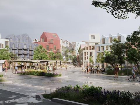
A new neighborhood is planned for development at Keldnaland in Reykjavík. The goal is to build an exciting modern neighborhood based on green transportation that supports a carbon-neutral urban community. Planning work is underway and the process is scheduled to finish in early 2026. This is a major development area and key site for housing construction in Reykjavík, with the completed neighborhood housing 12,000 people.
The Environment & Planning Council approved at yesterday's meeting to open the planning process by announcing a working draft of the municipal plan framework section along with draft development plan, design handbook and transportation plan. The matter was referred to the City Executive Council, and after approval, the data will be made available on the Urban Planning Portal where people can review the materials and share their views, which will be considered in the process.
The drafts are primarily based on planning work that FOJAB and partners have been doing over recent months in collaboration with Reykjavík City and Transport for the Capital Area.
Proposal in development
The municipal plan changes project description and FOJAB's award-winning proposal have been presented previously. The proposal has been further developed, including considering comments received on the project description. Examples include:
- The CityLine route has been better adapted to the landscape.
- Kálfamói and other important green areas have been given additional space.
- The margins of new neighborhoods have been better adapted to existing development.
The conservation process for Grafarvogur is ongoing and is being considered in the planning work. The Korpa River and its surroundings are already protected under the municipal plan based on a natural history survey. The proposed development is outside the protected area.
Development footprint reduced
The formation and development of proposals has been done in close consultation with Veitur Utilities and other city departments, including on the location of schools and preschools. There has also been active dialogue with stakeholders in the area, including about developing a business center.
The precise CityLine route through the area has been confirmed. New outdoor recreation areas and public spaces like Kálfamói have also been defined, and a city park has been designated.
Development has long been planned for the land of Keldur and surrounding areas. According to the current changes, the urban area footprint has been reduced by 28 hectares compared to the existing plan. The draft environmental assessment states that this change reduces the development's carbon footprint, increases its density and expands green open spaces. The neighborhood will therefore be even more walkable, better supporting green transportation, social interaction and public health.
Commercial space will primarily be located near CityLine stations where access is good for green transportation. The draft environmental assessment states that this makes it easier for people to commute to work using active transportation and supports daily life from morning to evening and shopping and services within the neighborhoods.
Events in August
Note that this is a working-stage proposal that will be announced on the Urban Planning Portal with a comment period until September 3. The purpose of the current presentation is to open the work process and give people an opportunity to share their views. The data is expected to be available on skipulagsgatt.is by the end of next week and will be accessible to everyone there. Events are planned for August at Keldar to present the proposal, and these will be advertised later.